 Over two years ago, I mentioned to my hiking buddy Tom Bricker that I was interested in finding some alternate locations to shoot in Yosemite as we were beginning to shoot the same locations over and over on our frequent visits. By that point, we had already been up the Four Mile Trail, Olmsted Point and out to Cathedral Lakes, but we began to look for other locations that were a bit more off of the beaten path.
A few weeks later, Tom came upon a blog post which listed several lesser known trails, some of which didn’t really exist or were difficult to find. At the top of this list was a location known simply as the Diving Board. Ansel Adams had hiked to this location quite some time ago and it was from this spot that hie took one of his most popular black and white photos in Yosemite. Both of us were hooked at this point, but we had no idea of what to expect as there didn’t seem to be a clearly defined trail to this location.
Several months later, we pulled up next to a photographer by the name of Jeff Mitchum in the parking lot of Pfeiffer Beach in Big Sur. We struck up a conversation and it turned out that Jeff had recently sold a print for over a million dollars, and that the photo for this print had been taken from the Diving Board. We pumped Jeff for as much info as we could get before he took off. He mentioned that the trail to the diving board was indeed difficult and maybe even a little bit dangerous. It would be best, he said, to try to tackle it in two days and simply camp up there over night. We were looking at a 3500 foot gain in elevation and something like a 16 mile round trip. “Crazy to try that in one day”, he said.
For two years, the diving board has been on my list. I had tried several trails in Yosemite, Glacier and the Canadian Rockies and some of these had almost finished me off so I was pretty sure that there was no way I could make it up there unless I was in much better shape. So I hit the treadmill and lost about 15 pounds. All Summer I had been ratcheting up my time on the treadmill, and after reading a couple more trip reports online, I finally felt ready to give it a try. I called Tom and he agreed to give it a try, because…you know. He’s just as crazy as I am.
So on August 19, we set of at 4 AM from my home in Orange County. By 10:30 AM, we were looking for any parking spot that we could find East of Curry Village as most of the hard core hikers using the John Muir Trail and Mist Trail were already parked and on their way up. I set off with just under 30 pounds of gear between my Nikon D750, and three lenses (14-24, 24-70 and the 12mm fisheye.) and about 3 liters of water. We felt pretty confident as we reached the trailhead knowing that the top of Vernal Fall was only 1.5 miles up. As my camera was in the backpack, most of the following trail shots were taken with my iPhone.

I was brimming with confidence on the way up to our first stop (last chance for water is as soon as you cross the bridge!) but then the real climbing began. Nothing but stairmaster until you get to the top of Vernal Fall from the bridge.

Once we reached the top of Vernal Fall, we headed further up the trail to Emerald pool where we filled up separate bottles for use with our filters with water from the Merced River:

It was all going pretty well at this point. I was REALLY tired after climbing the Mist Trail stairs but we filled up with water and now began to study the “shortcut” that we had read about in one of the Yosemite forums. We studied the map again using Gaia GPS on my iPhone and we set off following the approximate trail of someone who had gone up this way a couple of years before. This is the approximate trail that we took, taking off directly from Emerald Pool straight up the side of the mountain:

We were making good time even though it was warm. We headed straight up a granite slope and then turned around to admire the view:
 Then we plunged into the trees and all of the fun disappeared. We kept trying to follow the trail that two other hikers had left on the GPS, but there was NOTHING that even vaguely resembled a trail and we missed the turn up the mountain twice as we didn’t think they were serious. For those of you who go bushwhacking a lot, this probably would have been no big deal, but I was in trouble from almost the first moment we headed into the trees. It turned out to be roughly 2 miles or so of crazy steep terrain covered by lose leaves, huge mammoth boulders, underbrush and logs. The extra weight on my back definitely was’t helping as I had to continuously stop every hundred feet or so to catch my breath. I had the feeling that Tom would have made it up there in less than half of the time, but this climb was really taking a toll on me.
When we finally hit the junction with the regular “bush” route that other hikers have taken, we finally found a legitimate trail. Except this trail was even steeper than the mess we had just clawed our way through. My heart sank as I realized that there was no way I would make it to the Diving Board. I was clearly out of my league here. I was shaking, exhausted and afraid to drink too much water all at once, and I was starting to feel sick after overdosing on energy gel.
On the bright side, the views were getting more spectacular the higher we went. After another 30 minutes or so, I collapsed again for the upteenth time and I told Tom to just go on ahead without me. Tom refused and said he thought we should stick together as the trail was still pretty dodgy in spots.
Then it hit me. I didn’t REALLY need all of the stuff that was with me. What if I just took out what I didn’t need to get to the top and just grab it on my way back down?
I had no need for the 24-70 lens as there was so much haze in the valley, so that could go. It would still be light enough to hand hold my camera, so I could ditch my tripod. I didn’t need all of my water, or food, or my jackets….so out it all came. I left it all in a pile and suddenly my backpack was several pounds lighter. I felt like a new man! A really, really really tired new man, but a new man nonetheless.
I took one more break as we approached the top and then made the final push to the top up some of the steepest terrain of the day with the sound track to Rocky blaring inside my head.
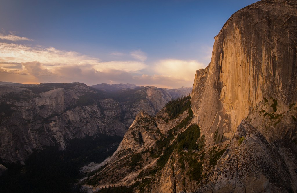
As I arrived at the top, gasping for air, I just stared with my mouth open. The ground just fell away in front of me, thousands of feet to the valley floor. And rising up in front of me, larger than I had ever seen it in my life, was the enormous face of Half Dome:

Blisters and pain were suddenly forgotten as Tom and I busied ourselves shooting for the next 45 minutes or so. It was golden hour when we arrived but it didn’t last very long. The clouds we had hoped would be behind Half Dome and moved too far West and were now blocking the sun that we had hoped would be shedding it’s last rays on the huge rock face in front of us. It was 6:30 as I arrived at the Diving Board. We had parked at 10:30AM. I think just the “shortcut” was 3 hours of hard climbing, but at least we had made it, eight hours after taking off. Here’s a shot of Tom shooting from the same location that Ansel Adams was at several decades ago:

And here are several more shots that I took before all of the light was gone for the day:


As we shot, we realized that had better take off soon if we wanted to save the last little bit of daylight on the way down, but as we shot, the clouds began to light up a bit and the glow from the clouds had begun to light up Half Dome. We stuck around longer than we should have waiting until all of the color was gone from the sky. Tom and I suddenly came back to our senses and we realized that if it took 8 hours to get up here, it was probably going to take at least that long to get back down, especially since there was NO chance of us going back down the way we came up in the dark.
We set off as fast as we could heading directly back down in a straight line, looking for the trail that we had come up on. In hindsight, this was a bad idea for a couple of reasons: 1) We had to crawl through a few hundred yards underbrush and downed logs (a bad combination in the dark) and 2) we didn’t really have a clear idea of where we had come up, aside from our GPS. We thought we were heading directly for the area that we had come up, but when I finally stopped to glance at the GPS, I saw that we had overshot the trail but that we could still meet up with it if we pressed straight ahead. We finally found the trail, but even with the GPS, we kept wandering off of it every couple hundred feet or so as it was just so hard to see with just our headlamps. There were cairns everywhere that other hikers had left, but unless our headlamps were directly on them, we just couldn’t see them in the dark.
As we started down the very steep trail, I asked Tom where he thought my gear might be. We both agreed that it must be further down so we pressed on. After a half hour or so, we were almost at the junction where we had come up and we still hadn’t seen the gear. At this point I began to panic. I was WAY too exhausted to head back up behind me, and if I didn’t find my pile of stuff, I would be out of water at that point. My last liter of water was sitting in that pile.
Tom bravely said he would head back up (this man runs marathons in his spare time) but returned 30 minutes later empty handed. It was now VERY dark, we were both almost out of water and we still had a 6 hour hike in front of us. I took a deep breath and accepted the fact that I would have to leave my gear lying up there behind me. Between the Nikkor 24-70 lens, my Benro tripod, two jackets, etc I was looking at at least a $2500 loss. But it couldn’t be helped. Our main focus at that point was water. We needed a water source and the sooner we found one, the better.
So down we went. My blisters were slowing me down horribly and I was trying to ration my last bit of water. Tom was virtually out. But we pressed on. Finding our way down the normal “bush” route proved to be a challenge as the path hopscotches all over the place, and even with the GPS, we had to backtrack several times to find it as it simply disappeared several times. Plenty of cairns around, but as you would spot one, the next sometimes was impossible to find. That GPS saved us several times over the 16 hours that we ended up hiking.
Long story short, we slowly worked our way around Lost Lake, which looked completely dry as it was August. We were just hoping to hold on long enough to make it back to the Merced River where we could fill up using our filters. Just when both of us were really beginning to dehydrate badly, we came across a small creek which cut across our trail and we filled up with some very cold water. I was using the Sawyer drinking straw for a filter, and even though the creek looked a bit dodgy in the dark, neither Tom nor I came down with Giardiasis. So thumbs up on the Sawyer Straw!
As we joined the John Muir Trail again, I was moving slower and slower. I finally sent Tom on up ahead with the car keys and asked him to bring the car around to the trail head as I figured the rangers wouldn’t mind if they knew I had been hiking for 16 hours on blistered feet and didn’t think I had it in me to make it the extra 1.5 miles or so back to Curry Village. Tom made it back down by 2:30 AM and fell asleep in the car waiting for me. I hobbled down around 3:30 and we drove down to Yosemite Village were both of us got a couple of hours of sleep.
When I woke up the next morning, I knew with certainty that there would be no more hiking that day for either of us. Going back up for my gear was out of the question, so we started the 6 hour drive back to Orange County. It hurt to leave my stuff up there, but I simply had no choice. It was a hard lesson for me to learn, but I just chalked it up to experience. I had lost some expensive gear before (like the time my 28-300 rolled off the cliff at Yosemite Point) but this one really hurt.
We had gone up on a Friday and come back the next day. On Sunday, I was still very sore, but a tiny bit better. By Monday, most of the pain had subsided and I began to wonder about my gear. I had turned in a lost and found report online with the rangers but had heard nothing back. There was also a chance of rain every day since that Friday that we had headed up. On Monday, the chance of rain jumped to 70 percent and I was convinced that even if my gear was there, it might be badly damaged.
By Monday afternoon, I decided to go for it. But this time I would do it right. The cheapest and closest alternative to staying overnight looked like the tent cabins at the Indian Flat RV park in El Portal. So I booked a cabin and spent the night. The next morning, I was up at 3 AM and by 4 AM I was at the trailhead heading up with a much lighter backpack, 3 liters of water and some food. I got off trail only twice in the dark (several tricky spots once you get above Vernal Fall in the dark) but by sunrise, I had made it to the top of Nevada Fall. Stopping only once for a short break and some snacks, I made it up to the turn off to the Lost Lake Trail and the lower bush route in just a couple of hours. On my way in I was treated to a beautiful sunrise. It turned out to be one of my favorite mornings I had ever spent in Yosemite. I kept checking the GPS and couldn’t believe how fast I was moving compared to my previous trip. By 8 AM, I knew I must be getting close.
And then i saw a hint of orange a bit off of the trail up ahead. I’m sure people must have heard me yelling from down in Mariposa. All of my stuff was still there and it was dry! No damage whatsoever! My lens, the tripod, two jackets, all of my food, Tom’s carrots, and my water….all exactly where I had left them. Turns out that not that many people take this particular trail and my stuff could have easily spent the entire Winter up there before someone came along.
On my way down, I decided to take the John Muir trail all the way down as I had never been on it before. Both the Mist Trail and John Muir trail offer stunning views and both should be added to your list if you have time while you are in Yosemite. Most of the hard core hikers headed for the top of Half Dome take the Mist trail as it is 1.5 miles shorter, but it definitely a work out. The John Muir Trail , while steep in sections, is not anywhere near as steep and features far less steps, i.e. it is much more gradual than the Mist Trail.
On my way down, I celebrated by feasting on power bars while soaking my feet in the Merced and just enjoying the beautiful morning. I then headed across the bridge at the top of Nevada Fall….

 and down the trail stopping whenever possible to grab a few shots with my phone. (I left the D750 at home as I was there strictly on a rescue mission.)

Again, epic views of both falls are available from either trail:

When Tom and I drove down the previous Saturday, we had both agreed that the trip was probably in the “once in a lifetime” category, but now that I have been up that trail twice, I’m actually thinking about heading back at some point. But on my next trip, there will be no shortcuts. If you are a mountain goat who loves scampering up ridiculously steep terrain and you can plow through a 3500 elevation gain like it’s no big deal, then the Emerald Pool route might be for you. But I actually made better time taking a lighter load around Lost Lake which was admittedly longer, but much more gradual. There are still some very steep sections to deal with and a couple of exposed sections where you are walking across some granite without much to hold on to, but for me, the lower bush route was MUCH easier than the crazy hike up from Emerald Pool.
Either way, I’m beginning to think I might have to try this again. Tom and I didn’t have the best light to work with while we were up there, and if we hit this in late Spring, the last light of the day should still be on Half Dome while we are shooting. The Diving Board is definitely recommended, but just make sure you know what you are getting into before you set off!
The other gentleman that sold his image for a million dollars…who would buy that for that amount?
As far as the gear I’m happy to hear you went back and found it in tact. I worried that you went back alone and might have gotten injured. Wonderful imagery.
Hi Mike. I have no idea who is putting out money like that to buy prints, even if they are sold as limited editions, but whatever he is doing, it’s definitely working! If someone wants to hand me a million bucks for a print, I certainly won’t turn them down. 🙂 I was a little concerned on my trip back, but I was surprised to see that much traffic on the Mist Trail at 4 AM. Most of the others were getting an early start on their trip to the top of half dome. I must have had at least 20 people around me at different times at 4 AM. It was only after I turned off toward Lost Lake that I was pretty much on my own, but I tried to be very careful, and I was checking in with Tom every hour or so to keep him updated. If Tom hadn’t heard from me, he would have notified the NPS with my location. Not something that I really wanted to tackle on my own, but I had the GPS with me and a good idea of where I had left my gear.
Wow what an amazing view up there! Having to leave equipment like that would have made me sick!! Glad to hear you were able to get it back and without it being damaged. Thanks again for sharing your adventures.
Thanks Darrin. It really ripped me up to leave all of that sitting up there, but I was already incredibly exhausted and the thought of spending another hour or so up there looking around in the dark with what we thought would be a 6 hour hike back to the car with only a small amount of water left…it was just too much. I’ve lost expensive lenses before (off a cliff or in the sand at the beach) so I just mentally tried to think of my stuff as going off a cliff. Of course, after I had a chance to rest and my blistered feet felt better, I knew I had to at least TRY to head back up there to look for it. That being said, I’m planning on being a bit more careful in the future. 🙂
Great adventure. I really enjoyed reading your post.
Thanks Yongsung!
Amazing to see what you captured and how the story ended so well. I know it didn’t feel well especially the days after (been there), before you went back for your gear. Fun to think we were up at Vernal together many years ago and that Kim and I took part of the John Muir trail a few years after. I love your photos. You and I see beauty in a similar way, you can just capture it far better than I can. Thanks for keeping me in the loop.
Hi Tim! Crazy to think that we were both up there so long ago. I spoke to Loren Wiebe not too long ago about how much those years meant to me. So sad to see some of the trees starting to die off in the Valley. I’ve heard that a record cold snap could kill most of them off so that is what I’m hoping for. As for Vernal…that was so much EASIER back in the 1980’s!!
I hate you! OK, I just mean I’m jealous 😉 Though your description of your day did remind me a bit of the misadventures of Bill Bryson in A Walk in the Woods.
My wife and I climbed Half Dome this past summer (we were on the trail at 6am) – so much wonderful scenery on the way. In fact, the views from the sub dome are fantastic (but the ranger sits at the bottom of it, so you still need a Half Dome permit to go up). We finished nearly 14 hours later, taking the long way down.
I shoot more opportunistically – in other words, we plan our trips around hikes, not pictures, so if I come across something to shoot – great! Lazily is another way to put it – I’m not scouting perfect locations/times of day… But my trusty Olympus om-d e-m1 (who names these things?) comes along and maybe one day I’ll get good! I mostly practice on hikes in the Santa Monica mountains, so the best subjects are little flowers, often less than an inch wide. I don’t put much up on flickr, but here: https://www.flickr.com/photos/149867803@N04/
I’m constantly tempting myself with APS-C or full frame camera shopping online (any recommendations?) – maybe one day I’ll get something different…
I see you went to the Dolomites – we were there a year ago in summer and loved it. We’re going back next summer – I can heartily recommend taking pictures and hikes in the Dolomites!
Hi Michael – So sorry to take a while to get back to you. I’m very jealous as I’ve never made it to the top of Half Dome. I might still try to get up there but I’m not too far away from 60 and every time that I look at the effort it takes to get up there on youtube, I definitely have second thoughts. I think if I were to try it, I might camp in Little Yosemite Valley overnight and then try to climb up in the morning while it was still cool. I honestly don’t know how people make it up that mist trail and then hike all the way back there and THEN head straight up that climb! It looks insane!
For a full frame camera, almost everyone I know has switched over to Sony. I think I will stick with my Nikon D850 and D750 for the time being, but I am definitely on the lookout for a lighter set up for backpacking. I was taking a hard look at the new Sigma FP which looks super light, but it’s getting mixed reviews, so I might need to hold off on that. The Fuji XT3 is getting better reviews, but it’s a crop sensor. I’m not necessarily locked into shooting full frame while I am backpacking at this point. I just need to shed some poundage on longer hikes. I made the mistake of hauling my ginormous Pro Media TR344L tripod around while I was shooting in Assiniboine and it nearly killed me. I decided at that point that I need an entirely different set up for longer hikes and backpacking trips. So I think ultimately I will hold on to my Nikon gear but will slowly begin adding a lighter system for backpacking. I am with you on the Dolomites! I can’t wait to go back!
Regarding Half Dome – it’s definitely very daunting! Getting in some general shape (a little upper body strength for the cables!) is recommended. Camping in LYV would really help keeping the effort reasonable. Of course, I also saw some people who didn’t look very athletic and managed it… Of course there are a lot of resources to be googled, but this site is packed with info: https://www.yosemitehikes.com/yosemite-valley/half-dome/half-dome.htm otherwise, good tread on your boots and a pair of gloves, plus any normal hiking essentials.
Regarding a new camera, thanks to some good luck with a Nikon N6006 something like 20 years ago, I’m partial to Nikon… I think I’ll wait and see how the Z series evolves. Some smaller lenses would be great – I’m even tempted by the Z50, but it needs a nice small standard length prime, ie, it’s version of a nifty-fifty, to convince me.
Oh, thanks for the Fave on flickr! That’s my first Fave 🙂 It’s silly how happy that made me.
Thanks for the tips on making it up to Half Dome. I have my eye on the Z series as well. I’m hoping to get something lighter within the next couple of years. And you’re welcome on the Flickr thing. You’ve got some great shots on there!